
Location-sharing for emergencies
Posted on 19 August 2021 by RJ Saftescu 

(The application can be used free of charge – currently under a donationware model.)
LockOnMe is a general-purpose location sharing application running on web and mobile, with the ability to display both static and dynamic (live) positions on maps and offline radar screens.
▹ When internet access is available, positions can be viewed (A) and also defined (B) on a standard web page – referred to as the Web Tracking Console or WTC – which can be accessed on mobile and desktop web browsers freely (without login) at lockon.me![]() .
.
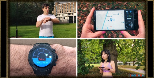
Additionally, the LockOnMe mobile app (Android | Wear OS![]() ) enables the continuous broadcasting of users' live locations from smartphones and smartwatches.
) enables the continuous broadcasting of users' live locations from smartphones and smartwatches.
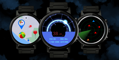
▹ When internet access cannot be guaranteed (C), the LockOnMe mobile app running on a standard GPS/GNSS-enabled smartphone or watch enables users to load positions (which were either pre-saved or sent by another user's LockOnMe app by SMS) or enter new coordinates (either already kept as written-down notes or received over the phone or radio transceivers) and can project these relative positions onto an offline radar view. It can also simply be used to display the users' own coordinates, for them to communicate by SMS (directly from the app), phone or radio.
A. VIEWING POSITIONS OVER THE INTERNET
Members of the public with access to the internet could be given a URL containing specific parameters in order to view pre-determined positions in the Web Tracking Console, like so:
https://lockon.me/?map=LightGray&track=EvacBrum/generic![]()
That URL may be communicated on a need-to-know basis, either publicly alongside other generic announcements, or delivered to certain individuals in particular.
Two features that may be practical for viewers:
- ability to display one's position, by clicking on the standard show my location icon in the top left-hand corner of the map
- choice between different map styles - such as satellite views, or a simplified style chosen for clarity – via the layers icon in the top right-hand corner of the map (the chosen style can be embedded in the URL):
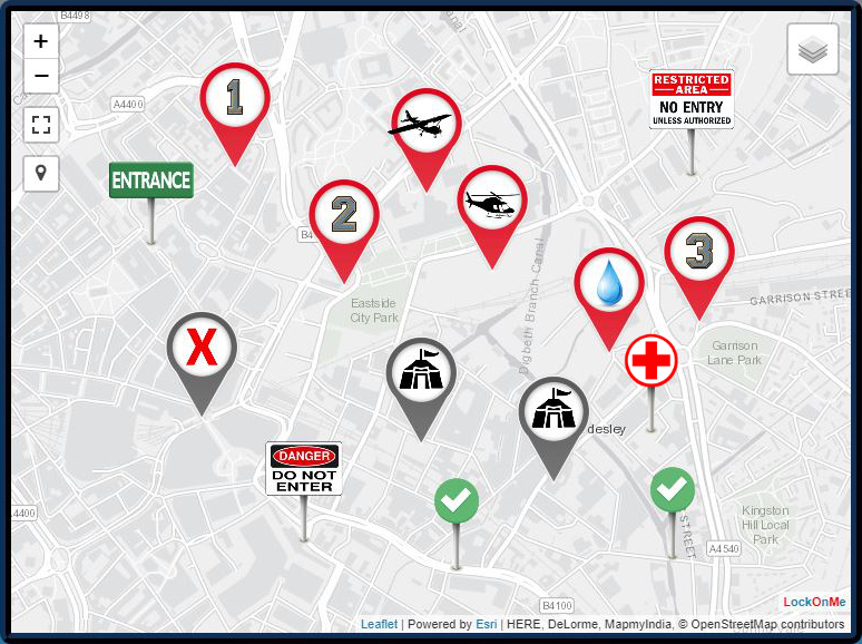
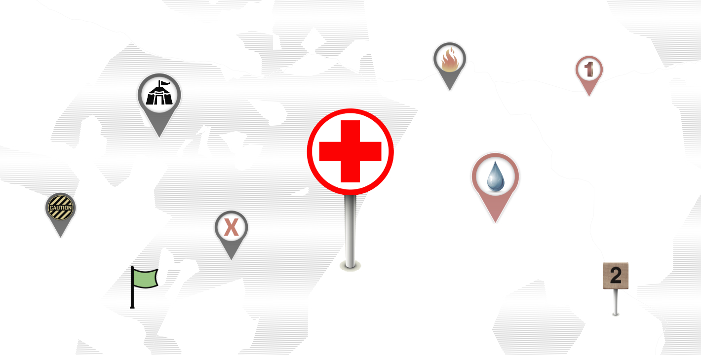
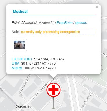
Markers are clickable, and convey extra information: title, note (optional), link to an image URL (optional), and geographic coordinates (lat/lon, UTM & MGRS):
A list of all positions appears in the Tracking pane of the Web Tracking Console:
The tracking pane opens by itself when loading the web page, so users don't have to look for it.
A more detailed description of its contents is given in the next section below.
B. DEFINING POSITIONS OVER THE INTERNET
Static positions may be defined in the Web Tracking Console in two different ways:
- by adding a fixed position (= the simple way)
- by using a Target (= the advanced way)
The easiest way is to right-click or long-press on the map at the exact spot where the marker should be created; a popup window will then invite the user to enter the position's name.
Fixed positions can also be defined based on location text or lat/lon | UTM | MGRS coordinates, via the Tracking pane; click/press on the Add button next to "Fixed positions".
Users can also search for a place via the lens icon on the left-hand side of the map.
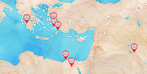
Multiple fixed positions may be defined in this way, resulting for instance in the following URL:
https://lockon.me/?fp=(-23.72501/45.36255/markerA),(-15.9402/48.35083/markerB)![]()
It is worth pointing out that the intended viewers do not need to get an understanding of the concepts described below. They would just have to be provided with a URL to open in their web browser (as seen in A), such as:
https://lockon.me/?map=LightGray&track=EvacBrum/generic![]()
This particular URL specifies the following target: EvacBrum / generic.
➪ A target is defined by a Target ID / Tracking Code pair; it may store static positions – referred to as Points Of Interests or POIs – and may also convey a live location.
To create a target, click/press on the Connect button of the Tracking pane, and then populate the fields with the target details of your choice; if the target is not already taken, it will become yours.
Once you are connected to your target, you will be able to define Points Of Interest via the Add POI button in the "Connected target" section; after clicking/pressing on a spot on the map, you will be prompted to enter a name, note & image URL (both optional), and to choose an icon.
Compared to defining fixed positions (1.), using a target to store POIs has the merits of conveying more information as well as regrouping all shared positions under a unique reference, which is more manageable – distribute the URL with the target details once to the target audience, and any change you make to the target's POIs will be instantly made available to the viewers tracking the target.
Note that creating different Cracking Codes for the same Target ID would result in distinct targets (such as EvacBrum / units_rally_points), each conveying its own set of POIs.
Multiple targets may be tracked at the same time, and passed via the URL parameters:
...&track=(EvacBrum/generic),(EvacBrum/units_rally_points).
The LockOnMe app (Android | Wear OS![]() ) is required in order to broadcast a target's live location. From the Connected Target screen, first connect to a target, and then switch on location broadcast.
) is required in order to broadcast a target's live location. From the Connected Target screen, first connect to a target, and then switch on location broadcast.
C. POSITIONING WITHOUT THE INTERNET
By using the LockOnMe app (Android | Wear OS![]() ) on their standard GPS/GNSS-enabled smartphone or smartwatch, users are first of all able to see their own coordinates – expressed in latitude/longitude, UTM and MGRS.
) on their standard GPS/GNSS-enabled smartphone or smartwatch, users are first of all able to see their own coordinates – expressed in latitude/longitude, UTM and MGRS.
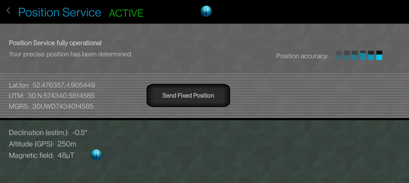
They would then be able to communicate their precise coordinates to relevant parties over the phone, radio, or by SMS.
There is a button on the Position Service screen to easily share the user's fixed position by SMS, in the form of a URL embedding the latitude and longitude as parameters.
In turn, that URL can be opened by the recipient's LockOnMe app directly, thereby retrieving the coordinates without the internet, and also without user entry (fast and error-proof).
In fact, any URL generated from the Web Tracking Console and containing fixed positions with geographic coordinates can be opened by the LockOnMe mobile app without the internet – and so, could potentially get communicated by SMS and/or sent by email in advance (assuming users would still be able to access their emails offline, or download a text file to their mobile device prior).
In addition to opening these special-format URLs, LockOnMe lets users manually enter geographic coordinates (which were already kept as written-down notes, or received over the phone or using radio transceivers) – expressed in latitude/longitude | MGRS – via the Add button on the Tracking Management System (TMS) screen:
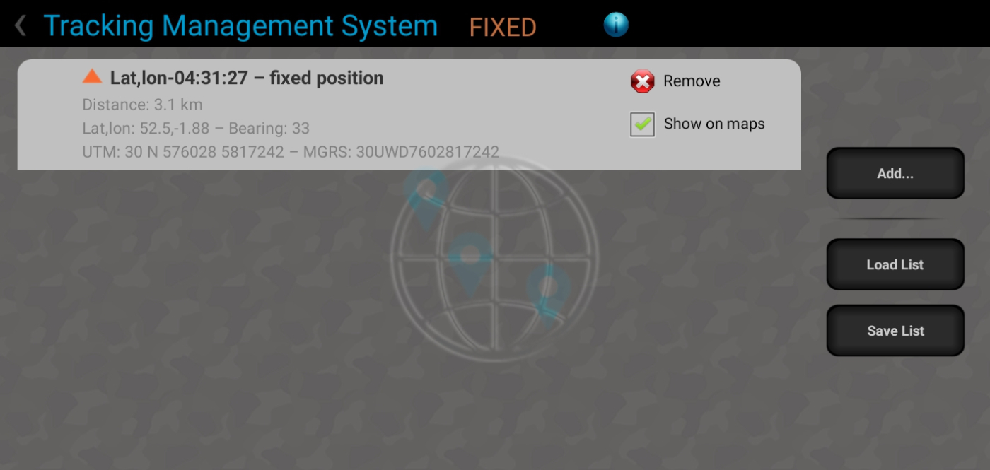
It is possible by the way to save a list of the tracking items shown on that TMS screen – both the fixed positions and also the targets and their POIs – via the Save List button, and load them offline afterwards.
Besides the textual information presented on the TMS screen (such as distance and bearing), graphical spatial representations, such as the Marine Radar view below, provide an intuitive UI for navigation and situational awareness:
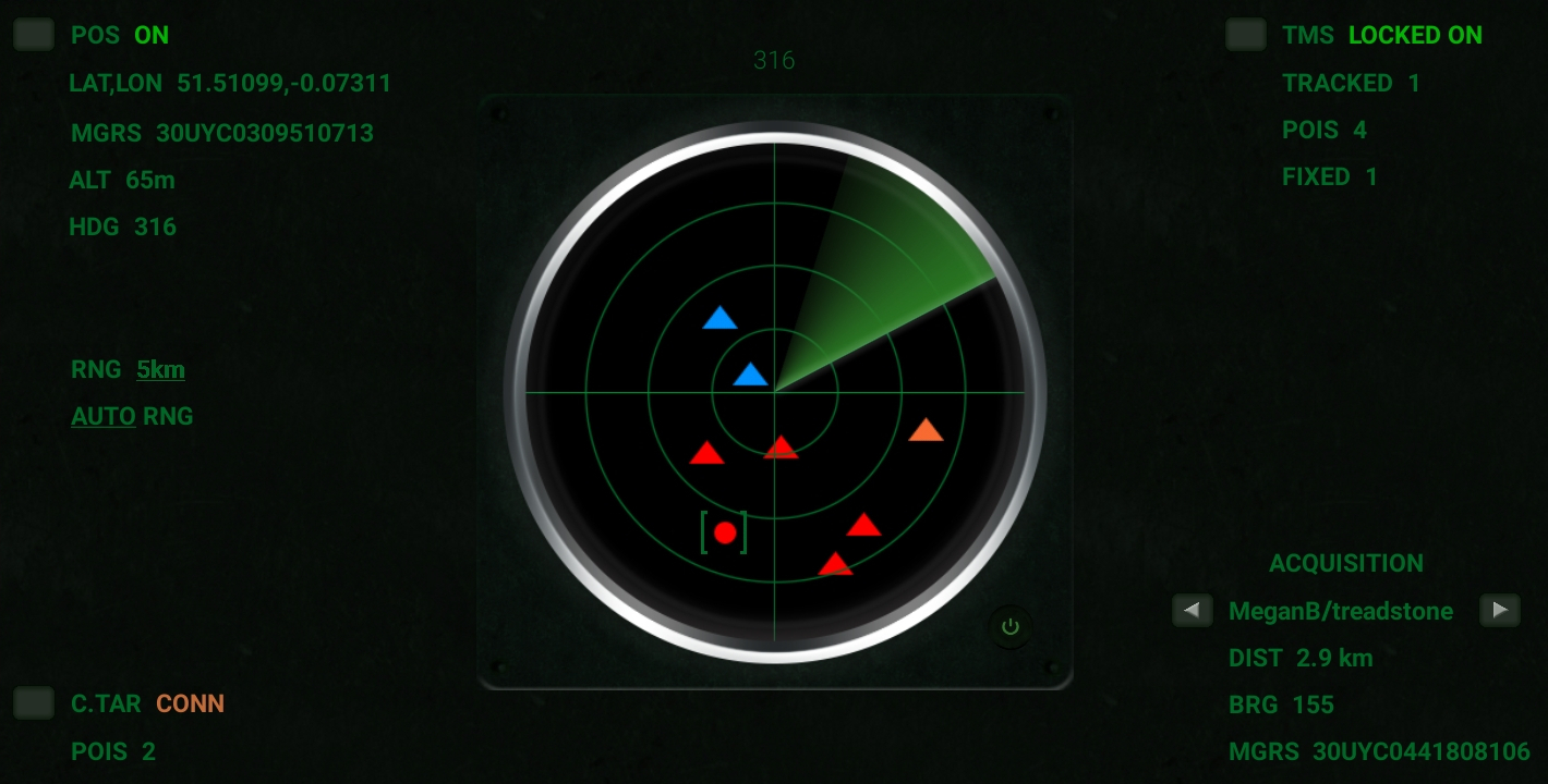
The LockOnMe radar views operate offline (insofar as they do not require the downloading of a map layer), and as such provide a viable alternative to its map view in absence of internet connectivity.
A more in-depth overview of the functionalities can be found in the User Guide![]() .
.
Contact us![]() for further enquiries, ad-hoc walk-through and training, application adaptation, etc.
for further enquiries, ad-hoc walk-through and training, application adaptation, etc.
In line with the terms of service no warranty can unfortunately be given at this stage in terms of service availability, redundancy in case of technical failure or system overload, nor any guarantee of any kind. In the absence of a service-level agreement, use it at your own risk.
last edited: 27 May 2024
°•◦♠♡♢♣♤♥♦♧●◯